|
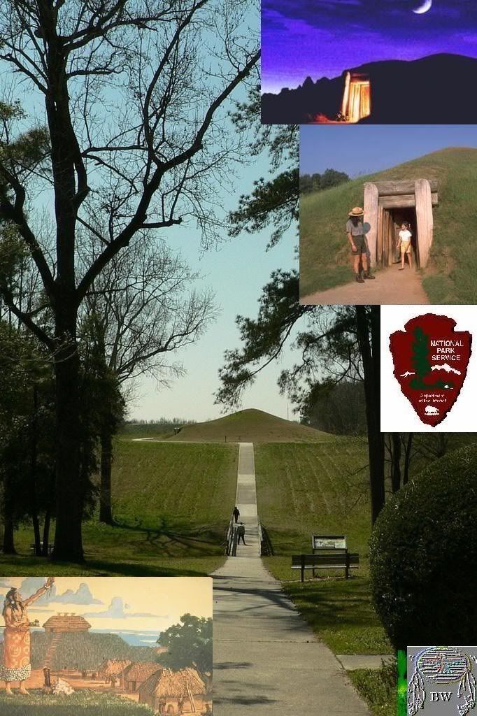
Ocmulgee Mounds and Earth Lodge 9,000 BC
Ocmulgee National Monument Macon Georgia
Some of the largest Indian Mounds in the state of Georgia, the Ocmulgee Mounds on the Macon Plateau are a significant part
of Georgia history. Built during the Early Mississippian Period, the mounds were the centerpiece of a culture known as the
Moundbuilders.
Moundbuilder history
Archaic Moundbuilders may have developed in Louisiana, spreading north to inhabit the rich valleys of the Mississippi and
its tributaries, and following other coastal rivers inland. Around 1000 BC the first mounds appeared in the present-day state
of Georgia. These mounds, some of which were located on the Macon Plateau, were similar in many ways to mounds built in other
places throughout the Eastern United States.
Near the Ohio River two distinct cultures of Moundbuilders arose, first the Adena (400? BC) and then the Hopewell (100 BC).
By 500 AD, the Hopewell appear to have been in decline. From the west came the Mississippians, in about 900 AD. Some Georgia
mounds, especially Kolomoki, exhibit traits of both civilizations.
The Mississippians
Built on a complex socio-political structure with advanced agricultural techniques, including perhaps crop rotation, the Mississippian
culture spread throughout much of the Eastern United States. They used waterways as a major form of transportation, and had
an extensive trading network.
Moundbuilders at Ocmulgee
Between 900 and 950 AD the mounds at Ocmulgee were constructed. Over the next 300 years the Moundbuilders inhabited this site,
considered to be the largest village in the Southeast. During this time period the Great Temple Mound was constructed, along
with the other lesser mounds and earth lodges nearby. By the end of the Early Mississipian Era (1200 AD) the mounds at Ocmulgee
were in decline, while the Etowah Indian Mounds were flourishing.
Then, sometime after 1300AD a second culture, known as the Lamar culture, began to flourish near the Ocmulgee mounds. This
site, not far from the Ocmulgee Mounds and within the same National Park area features a unique "spiral" mound, funeral mound,
and other small mounds. The Lamar Culture spread throughout the Southeast and had contact with non-Moundbuilder tribes such
as the Cherokee.
The Ocmulgee Indian Mounds history
First mention of the mounds is by a member of James Oglethorpe's Georgia Guard who saw the mounds on a trip with Oglethorpe
to the Creek capital of Coweta. Naturalist William Bartram noted Ocmulgee on both his visits to the site during the 1770's,
calling them the "Oakmulgee fields". The mounds remained in Creek hands well into the 19th century, and were exempted from
a treaty ceding the surrounding area. The mounds, however, were finally ceded to the state and distributed to settlers (1828).
Macon's rapid expansion during the 1800's compromised the mounds with incursions to build railroad lines and public works
projects. By 1930 the mounds had been heavily damaged. A group of concerned citizens and the Smithsonian Institute organized
an excavation of the Ocmulgee Indian Mounds to prove their archeological value. Noted archeologist Dr. A. R. Kelly led the
expedition. Based on Kelly's finds, the Ocmulgee National Park was created in 1936.
Today the park continues to grow thanks to donations of nearby land. It struggles to maintain the land as intact as possible
not only for this generation but for future generations as well.
OCMULGEE CHRONOLOGY
pre-9,000 BC Paleo Indian Period
Ice Age hunters arrive in the Southeast, leaving one of their distinctive "Clovis" spear points on the Macon Plateau (in the
1930's this became the first such artifact found in situ in the southern U.S.).
8,000-9,000 BC Transitional Period
People adjust to gradually warming weather as the glaciers melt and many Ice Age mammals become extinct.
1,000-8,000 BC Archaic Period
Efficient hunting/gathering; adaptation to a climate much like today; use of the atlatl (spear thrower), woodworking tools,
etc.; white-tail deer becomes a staple; extensive shell mounds along the coast and some inland rivers.
2,500 BC First pottery in this country appears along the Georgia/South Carolina coast and
soon filters into what is now Middle Georgia; it is tempered or strengthened with plant fibers which burn out during firing,
giving a worm-hole appearance to the vessel surface.
1,000 BC-AD 900 Woodland Period
Pottery tempered with sand and grit, sometimes decorated with elaborate designs incised, punctated or stamped into its surface
before firing; cultivation of sunflowers, gourds, and several other plants; construction of semi-permanent villages; stone
effigy mounds and earthen burial and platform mounds; connections to the Adena/Hopewell Cultures farther North and to Weeden
Island in Florida and South Georgia.
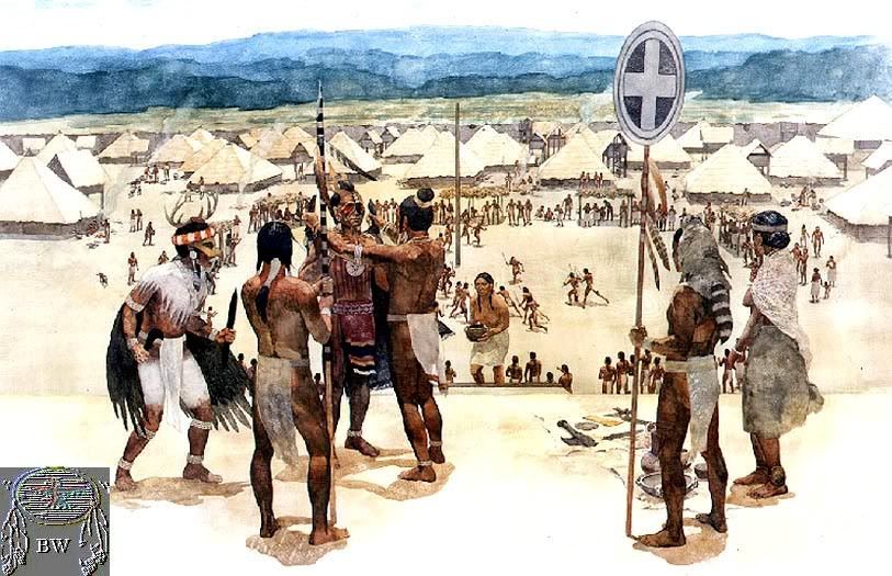
A.D. 900-1150 Early Mississippian Period
A new way of life, believed to have originated in the Mississippi River area appears on the Macon Plateau. These people,
whose pottery is different from that made by the Woodland cultures in the area, construct a large ceremonial center with huge
earthen temple / burial / domiciliary mounds and earthlodges, which serve as formal council chambers. Their economy is supported
by agriculture, with corn, beans, squash and other crops planted in the rich river floodplain. Indigenous Woodland people
in surrounding areas interact with these people, who possess early symbols and artifacts associated with the Southeastern
Ceremonial Complex (Southern Cult).
1150-1350 Mature Mississippian Period
The great Macon Plateau town declines and the Lamar and Stubbs Mounds and Villages appear just downstream. These towns are
a combination of the old Woodland culture and Mississippian ideas. The Southern Cult, distinguished by flamboyant artistic
motifs and specialized artifacts, flourishes at places like Roods Landing and Etowah (GA), Moundville (AL), Hiwasee Island
(TN), Cahokia (IL), and Spiro (OK).
1350-1650 Late Mississippian Period (Protohistoric)
The Lamar Culture, named for the Lamar Mounds and Village Unit of Ocmulgee National Monument, becomes widespread in the Southeast;
chiefdoms marked by smaller, more numerous, often stockaded villages with a ceremonial center marked by one or two mounds;
combination of the both Woodland and Mississippian elements.
1540 Chroniclers of Hernando DeSoto's expedition into the interior of North America write the first descriptions
of the Lamar and related cultures, ancestors of the historic Creek (Muscogean), Cherokee (Iroquoian), Yuchi (Euchee), and
other Southeastern people. Most of their main towns are situated near rich river bottomland fields of corn, beans and squash.
Many towns feature open plazas and earthen temple mounds. Public buildings and homes are constructed of upright logs, interwoven
with vines or cane and plastered with clay (wattle and daub). Some are elaborately decorated and contain large woodcarvings.
DeSoto’s expedition’s 600 men and 300 horses devastate local food supplies; epidemics of European diseases decimate
many populations.
1565 The Spanish establish their first permanent settlement at St. Augustine, set up outposts at towns along the Atlantic
coast to the North, and begin to missionize the Indians. Priests and soldiers travel up the river systems to other towns
in the interior of the area which would become Georgia.
1670 The British establish Charles Town (Charleston, SC) on the Atlantic coast. Despite Spanish opposition, English
explorers initiate contact and trade with towns in the interior.
1690 A British trading post is constructed on Ochese Creek (present Ocmulgee River at the site now protected within
Ocmulgee National Monument). A number of Muscogee towns move from the Chattahoochee River to this vicinity to be near the
English. At this time, the Ocmulgee river is called Ochese-hatchee or Ochisi-hatchi (various spellings). The towns are known
as the Ochese Creek Nation. The British eventually refer to them simply as the "Creeks." They speak variations of the Muscogean
language, but their confederacy incorporates other groups, such as the Yuchi, who speak different languages. The Creeks acquire
horses from Spanish Florida and guns from the British. Their culture and dress is modified by use of trade goods such as
iron pots, steel knives, and cotton cloth.
1704 Col. James Moore, with a band of some fifty men from Charles Town, leads 1,000 warriors from the Creek towns on
the Ocmulgee River to Florida. They devastate the Spanish Apalachee Mission system and drive the Spaniards back to St. Augustine.
After many of the inhabitants of northern Florida are exterminated, some of the Creeks move into the area and incorporate
the survivors into their own group. These people are subsequently known as the Seminole and Miccosuki.
1715 The Yamassee War erupts in protest against British indignities related to the fur trade, including the taking of
Indian shipped as slaves to work in Carribean sugar plantations. Many traders in Indian territory are killed. In retaliation,
the British burn Ocmulgee Town on Ochese Creek. The Creek towns withdraw to the Chattahoochee River and the Yuchis move with
them. The people are known as the Lower Creeks. The Upper Creeks are centered on the Coosa and Tallapoosa Rivers to the northeast.
1733 The Georgia Colony settles on lands along the banks of the Savannah River given to General James Oglethorpe by
Chief Tomochichi of the Yamacraws, a group related to the Lower Creeks. The Colony serves as a buffer between South Carolina
and Spanish Florida.
1739 General James Oglethorpe, founder of the Georgia Colony, travels the ancient trading path through the mounds and
old planting fields at Ocmulgee enroute to Coweta (near what is now Columbus, GA) to meet with the Creeks. One of his Rangers
writes a short description of the mounds at what is now Ocmulgee National Monument. A western boundary for the colony is
defined along the Ogeechee River. The area extends along the coast to the present northern border of Florida.
1774 William Bartram, reknown naturalist and botanist, follows the Lower Creek Trading Path from Augusta
through the area. In his journal, he records this account of the Ocmulgee Old Fields:
"On the heights of these low grounds are yet visible
monuments, or traces, of an ancient town, such as artificial
mounts or terraces, squares and banks, encircling considerable
areas. Their old fields and planting land extend up and down
the river, fifteen or twenty miles from this site. If we are to
give credit to the account the Creeks give of themselves, this
place is remarkable for being the first town or settlement, when
they sat down (as they term it) or established themselves, after
their emigration from the west..."
1778 During the Revolutionary War, many Creeks want to remain neutral, but Alexander McGillivray (of Creek-Scottish
descent,educated in South Carolina, Principal Chief of both the Upper and Lower Creeks) leads them into an alliance with England.
1793 Invention of the cotton gin greatly accelerates the desire for rich river bottomland. Creek Indians, most
of them excellent farmers, quickly adapt to a cotton-based economy.
1805 The first Treaty of Washington cedes the remainder of the land between the Oconee and Ocmulgee Rivers, excluding
a 3x5-mile strip known as the Old Ocmulgee Fields Reserve at present Macon, which the Muscogee (Creek) people refuse to give
up. The treaty allows the United states to construct a road across the Creek Nation to the Alabama River and facilities for
public accomodations along this road. Much of this "Federal Road" follows the ancient Lower Creek Trading Path and eventually
stretches from Washington, D.C. to New Orleans. The treaty also provides for a United States military fort on the
Reserve to guard the frontier along the Ocmulgee River. This outpost is called Fort Hawkins in honor of Benjamin Hawkins,
U.S. Indian Agent to the Creeks and friend of George Washington.
1806 Fort Hawkins is built a short distance from the mounds. It serves as a frontier outpost, trading and center
and location for treaty payments to the Creeks until the United States boundary is later extended to Alabama Territory. For
the entirety of its existence as a U.S. military fort, it sat on land owned by the Muscogee (Creek) Confederacy.
1811 Shawnee Chief Tecumseh, working with his brother the Prophet, travels up and down the frontier exhorting the
Native Americans to discard their plows, whiskey and the white man’s ways. Some of the Creeks join his movement and
nearly every town has a so-called "Red Stick" faction. The leaders are as divided as their people. William McIntosh emerges
as leader of the faction loyal to the U.S. government. William Weatherford (Red Eagle) becomes the most important leader
of the Red Sticks.
1812 General Andrew Jackson (later President) stops at Fort Hawkins during the War of 1812. The fort is an important
port of rendezvous for dispatching troops. This war with Great Britain concerns the issues of neutral maritime rights and
British involvement in Native American problems along the frontier. Hostilities between Creek loyalists and traditionalist
Red Sticks increase. Red Sticks attack and destroy Tuckabatchee and several other Upper Creek towns in northern Alabama.
1819 The ancient Lower Creek Trading Path, now called the Federal Road, is the major artery from North to Southwest
for many years (State Highway 49 follows much of this route through Central Georgia). It serves as the postal route from
New York to New Orleans. A ferry is built near the mounds on the Old Ocmulgee Fields Reserve, and the first white child,
later Mrs. Isaac Winship, is born in the area.
1821 The Creeks give up the lands between the Ocmulgee River and the Flint River.
1823 The Creek Council passes a law providing the death penalty for anyone ceding land without the authority of
the Council. Pressures for Indian removal continue to increase. Some Creeks, including William McIntosh, believe removal
is inevitable.
The City of Macon is laid out across the river from Fort Hawkins. The first newspaper in Middle Georgia, the Georgia Messenger,
is published at Fort Hawkins, and a post office is established.
1825 The Treaty of Indian Springs ceding the last Creek lands in Georgia is signed by Chief William McIntosh.
His cousin is the governor of Georgia. He sells the Creek lands and is consequently assassinated by his own people. The
treaty is declared illegal by the federal government, but Georgia authorities disagree. They press harder for removal.
1826 The second Treaty of Washington officially surrenders the last Creek lands in Georgia. Some of the Creeks
join the Seminole in Florida, others move into Alabama. About 1,300, mostly members of the McIntosh faction, resettle to
the valley of the Arkansas River in "Native American Territory," now the state of Oklahoma, on lands given to them under the
government’s voluntary removal program
1828 The Old Ocmulgee Fields Reserve, including Fort Hawkins and the mounds, is surveyed and laid off into land
lots incorporated into the city of Macon. Roger and Eliazar McCall purchase a portion of the Old Fields and establish a successful
flatboat manufacturing enterprise. Of the mound area, the local newspaper reported:
"The site is romantic in the extreme; that, with the burial
mounds adjacent, have long been favorite haunts of our
village beaux and belles, and objects of curiosity to strangers.
We should regret to see these monuments of antiquity and of
our history levelled by the sordid plow - - we could wish that
they might always remain as present, sacred to solitude, to
reflection and inspiration."
1836 The Creek War of 1836 ends when about 2,500 people, including several hundred warriors in chains, are marched
on foot to Montgomery, AL, and crowded onto barges during the extreme heat of July. They are carried by steamboats down the
Alabama River, beginning their forced removal to Indian Territory. During the summer and winter of 1836-early 1837, over
14,000 Creeks make the three-month journey to Oklahoma, a trip of over 800 land miles and another 400 by water. Most leave
with only what they can carry.
1839 The Cherokee begin their "Trail of Tears." A few escape and remain in the mountains of East Tennessee and
North Carolina where most of their descendants now live on the Qualla Reserve around Cherokee, NC.
1843 The Central Railroad constructs a railroad line into Macon through the Ocmulgee Old Fields destroying a portion
of the Lesser Temple Mound and the great prehistoric town. A locomotive "roundhouse" is located near the Funeral Mound.
1840 The huge oak trees on the mounds are cut for timber. Until this time, the Old Ocmulgee Fields and Brown’s
Mount (another scenic prehistoric town about 6 miles down river) had been favorite resorts for picnics and parties, first
by the officers at Fort Hawkins then by the residents of Macon.
Much of the Macon Plateau site becomes part of the Dunlap Plantation. Clay for brick manufacturing is mined near the Great
Temple Mound and a fertilizer factor is constructed nearby.
1864 Union General George Stoneman nears the city of Macon in July. Governor Brown, who is in Macon, calls for every
able-bodied Man to defend the city. A battery is stationed near the site of Fort Hawkins. Big guns are loaded on flatcars
at the railroad bridge
over the Ocmulgee River inside the boundary of what is now the Ocmulgee National Monument. Gen. Stoneman destroys Griswoldville,
continues to Macon and burns the railroad bridge over Walnut Creek on the Dunlap property. He uses the Dunlap's farm house
as his headquarters during the ensuing battle. Failing to take the city, Stoneman and his troops are pursued into nearby
Jones County, where they are defeated at Sunshine Church. General Stoneman and his officers are incarcerated at Camp Oglethorpe
in Macon and his enlisted men are sent to the infamous prisoner of war camp at Andersonville. Stoneman is the highest ranking
Union officer taken prisoner during the Civil War.
1874 A second huge cut for a railroad (still in use) is excavated through the mound area and destroys a large portion
of the Funeral Mound. According to Charles C. Jones, in his book, Antiquities of the Southern Indians, many relics and human
burials are removed during this work.
1933 A large portion of McDougal Mound is removed to use as fill dirt for Main Street. Motorcycle hill-climbing
leaves scars on the slopes and summit of the Great Temple Mound. A group of local citizens are convinced that the mounds
are of great historical significance and should be preserved. Led by General Walter A.Harris, Dr. Charles C. Harrold, and
Linton Solomon, they seek assistance from the Smithsonian Institution, which sends Dr. Arthur Kelly to organize and conduct
archeological excavations on the Macon Plateau.
1934 Archeological treasures are unearthed. As the work progresses, a bill is passed by Congress to authorize establishment
of a 2,000-acre Ocmulgee National Park. The archeological effort is largest excavation ever, until this time, undertaken
in the country. Labor is provided by hundreds of workers employed under several Great Depression-era public works programs.
1936 President Franklin D. Roosevelt on December 12th signs the Proclamation establishing Ocmulgee National Monument
and directing the National Park Service to preserve and protect 2,000 acres of "lands commonly known as the Old Ocmulgee Fields..."
Due to economic constraints, only 678.48 are acquired, including 40 acres at the detached Lamar Mounds and Village. Later,
an additional 5 acres are added to the Lamar Mounds and Village Unit and the parcel known as Drakes Field is donated to the
nation for inclusion in Ocmulgee National Monument by the City of Macon. The park presently encompasses 702 acres.
1940 Great Depression Relief-era crewmen, including members of Civilian Conservation Corps Company 1426 stationed
at Ocmulgee National Monument, are drafted into military service as the United States enters World War II. Man are sent to
nearby Camp Wheeler which becomes the largest infantry training camp in the nation.
1960's An interstate highway (I-16), constructed through the Macon Plateau Unit, cuts the primary visitor use area
off from the park's mile-long river boundary and causes significant hydrological changes to lands located in the river floodplain.
During archeological excavation within the highway corridor inside the park, evidence of Muscogee (Creek) and earlier settlement,
along with three human burials, are discovered. A number of important prehistoric and historic sites outside the park are
destroyed or heavily damaged, including the nearby Gledhill I, II and III (where an Ice Age Clovis spearpoint is found by
an artifact collector during removal of fill dirt for road construction), along with the New Pond site, Adkins mound, and
Shellrock Cave. Archaic, Woodland, Mississippian and historic Creek villages and campsites across the river, such as Mile
Track, Napier, Mossy Oak and Horseshoe Bend, are already damaged by levee construction in the 1940's.
1970's The Swift Creek Mounds and Village, type-site for a widespread Woodland Period culture, is destroyed for construction
of a Bibb County Sheriff's Department firing range. Dr. Kelly's early archeological collections, still under the care of
the National Park Service, are all that remain of this large site, which was located on the Ocmulgee Old Fields near the Lamar
Village Unit of Ocmulgee National Monument.
1992 Descendants of Roger and Eliazar McCall donate almost 300 acres, adjoining the park's Walnut Creek boundary,
to the National Park Service. The Archeological Conservancy accepts ownership pending legislation to incorporate it into
Ocmulgee National Monument. The land, owned by this family for almost 175 years, has been designated the Scott-McCall Archeological
Preserve.
1997 The Old Ocmulgee Fields are determined eligible to become the first National Register of Historic Places listing
for a Traditional Cultural Property, or District, east of the Mississippi River. This distinction recognizes the area's great
significance to the Muscogee (Creek) people.
Present The park's staff, the OcmulgeeNational Monument Association, the Friends of Ocmulgee Old Fields, and the
park's many volunteers remain dedicated to the mission of protecting and preserving this very special place for the enjoyment
of today's citizens and future generations.
http://www.nps.gov/ocmu/index.htm

LINK TO BRAVEHORSE WARRIORS VOLUME TWO
|